Record Ocean Warming Signals Arrival of Potential Super El Niño in 2026
Meteorologists and climate agencies are sounding an “Atmospheric Code Red” as latest oceanic data confirms a major El Niño is intensifying beneath the Pacific surface.
Current satellite observations and subsurface buoys indicate that sea surface temperatures (SST) are rising rapidly, marking a definitive end to the consecutive La Niña winters experienced recently.
Forecast models from major global authorities, including NOAA and the European Centre for Medium-Range Weather Forecasts (ECMWF), now align on a high-impact trajectory for the remainder of 2026.
- Forecast Confidence: European models currently predict a nearly 100 percent chance of a powerful El Niño developing by late fall.
- Threshold Breach: Several forecasts suggest water temperatures in the Niño 3.4 region could exceed 2.0°C above seasonal averages.
- Extreme Projections: Some ensemble members indicate intensification could push anomalies into the extreme +3.0°C range.
This subsurface heat pulse, known as a Kelvin wave, is currently migrating toward the surface, acting as a release valve that will reorganize global weather patterns.
US Weather Forecast: Cooler Summers and Bizarre Winter Transitions
The emergence of a Super El Niño typically disrupts seasonal norms across North America, starting with a shift in the Pacific jet stream.
For the United States, this climate transition often results in a “Wet, Hot American Summer” in some regions, while others experience uncharacteristic cooling and increased storm activity.
In states like New York, past Super El Niño events have led to unseasonably warm winters where temperatures reached 70 degrees even in late December.
- Southern United States: Anticipated increase in rainfall and higher risk of tropical storm remnants.
- Northern United States: Historically drier and warmer conditions during the winter months.
- Western US: Above-average heat expected through summer and fall, specifically in the Southwest.
Climate scientists at National Weather Service tracking centers emphasize that while the spring predictability barrier can limit early certainty, current data is unusually strong.
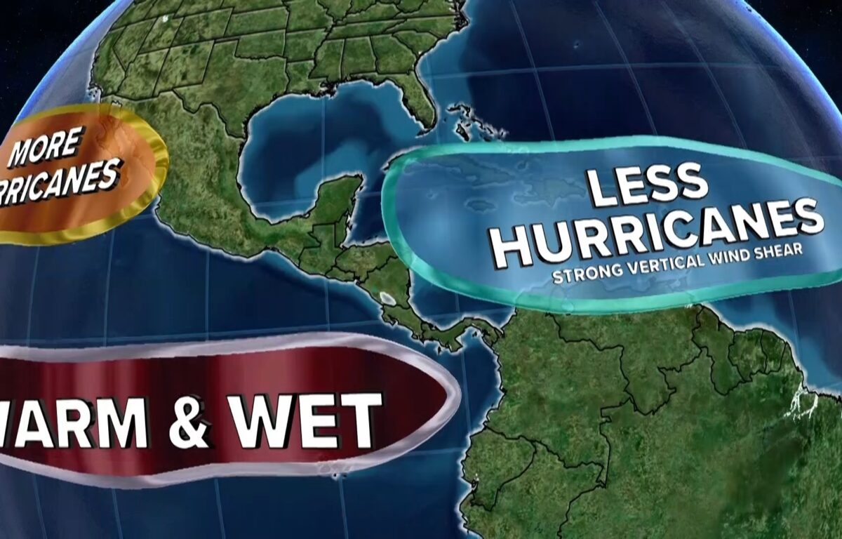
Impact on the 2026 Hurricane Season
The developing El Niño is expected to play a decisive role in the 2026 hurricane season for both the Atlantic and Pacific basins.
Typically, El Niño conditions increase vertical wind shear in the Atlantic, which can act to break apart developing tropical systems before they strengthen.
However, the unprecedented levels of extreme weather events driven by record ocean heat may counteract the typical suppressing effects of El Niño in the Atlantic.
- Atlantic Outlook: Forecasts call for approximately 13 named storms and six hurricanes, which is near the historical average.
- Pacific Outlook: Warmer waters in the central and eastern Pacific often lead to more frequent and intense hurricanes in those regions.
- Historical Precedent: During the 2015-2016 Super El Niño, 16 tropical cyclones formed in or passed through the central Pacific basin.
Experts warn that the sheer volume of subsurface warm water anomalies is as large as any seen in modern history, providing immense energy for potential storms.
The Role of Subsurface Kelvin Waves
The physical engine behind this warming is a massive oceanic Kelvin wave currently being pushed eastward across the tropical Pacific.
These waves are driven by westerly wind bursts or weakened trade winds, which allow warm subsurface water to migrate and eventually rise to the surface.
Meteorologists are comparing the 2026 data against the record-breaking events of 1877 and 2015 to gauge potential severity.
| Event Year | Peak Intensity (Anomaly) | Classification |
|---|---|---|
| 1877-1878 | Estimated +2.5°C | Super El Niño |
| 1997-1998 | +2.4°C | Super El Niño |
| 2015-2016 | +2.6°C | Super El Niño |
| 2026 (Projected) | Targeting >+2.0°C | Super El Niño |
The World Meteorological Organization (WMO) notes that while they do not officially use the term “super,” the current intensification is outpacing historical benchmarks.
Global Temperature and Rainfall Disruption
Beyond the United States, the reorganization of the atmosphere will have a nearly global dominance of above-normal land surface temperatures.
Wilfran Moufouma Okia, Chief of Climate Prediction at WMO, stated that climate models are now strongly aligned, signaling high confidence in the onset of the event.
The combination of human-induced climate change and a powerful El Niño could push global temperatures past critical warming thresholds.
- South America: Increased rainfall in southern parts of the continent, leading to flood risks.
- Australia & Indonesia: High risk of severe drought as moisture shifts toward the eastern Pacific.
- Central Asia: Likely to experience increased precipitation and potential storm volatility.
Scientists suggest that this event could permanently push the global average temperature past 1.5 degrees Celsius above pre-industrial levels.
Infrastructure and Economic Readiness
Agricultural and energy sectors are already being advised to prepare for the “code red” atmospheric scenario currently trending toward record intensity.
The Fox Forecast Center indicates that the current May predictions are a significant indicator of an event that Americans will look back on for years to come.
In the Southwest and Intermountain West, the primary concern is the potential for sudden downpours and flooding from tropical remnants.
Conversely, the Northwest may face severe water supply shortages and prolonged drought conditions throughout the cycle.
The transition is expected to continue through 2027, with the strongest impacts likely arriving later in the current season as the system fully intensifies.
Meteorologists like Jeff Berardelli emphasize that we are likely to see weather events never before witnessed in modern history due to the redistribution of planetary heat.